This site is near and dear to my little heart, perched on the hill west of the historic site of the Colony of Avalon at Ferryland, Newfoundland. It was one of the sites I explored during my MA thesis (see my publications for a link to the thesis, or wait a few months for the book!), and come to think of it I could very easily populate this series with all NL sites from my thesis research. Would anyone want to read that? Maybe?
Exposed to the often harsh and relentless winds of the North Atlantic ocean, anyone visiting graves in Ferryland in the 18th and 19th centuries would have had an unobstructed view of any passing ice bergs or whales!
View of the Colony of Avalon from the burial ground (photo by author 2015)
I’m excited to be able to share my public burial archaeology paper, “Public Engagement through Burial Landscapes: Cupids and Ferryland, Newfoundland” with all of you!
It was released today, along with many other articles on public burial archaeology in AP: The Online Journal in Public Archaeology’s Special Volume 3: Death in the Contemporary World: Perspectives from Public Archaeology.
My article discusses ‘lost’ burial grounds – burial grounds which are known to exist, but have yet to be identified – like the 17th-century burial ground at Ferryland, and how discussion with visitors on historic burial practices can often lead to a dialogue on modern burial practices.
If you are interested, I’ve put a link HERE, where you can download the entire volume or each paper individually. It’s an open-access journal too, which is amazing! (If you’re going to do a Public Archaeology journal, it really should be open-access or it’s negating its own point.) I’m so pleased to be able to share this research with you all. While you’re at it, check out the amazing papers by everyone else in the volume, it’s chalked full of deathy-arch goodness!
Citation:
Lacy, Robyn S. 2018. Public Engagement through Burial Landscapes: Cupids and Ferryland, Newfoundland. AP: Online Journal of Public Archaeology, Special Volume 3: Death in the Contemporary World: Perspectives from Public Archaeology. Pp. 55-78. Available online: http://revistas.jasarqueologia.es/index.php/APJournal/issue/view/14/showToc
Well here we are, the final week of my Masters excavation! The title of this post may say week 4, but including last year’s dig this would be week 10. Week 10! For a Masters, I believe that is a bit more time spent digging than was necessary for the degree, but in terms of pursuing the questions I was asking… maybe it wasn’t enough time?
We’ll have to wait and see! We got up to quite a bit at Ferryland this week, and I spent part of the week gathering my thoughts about the research, the end of a major part of my project, and what conclusions we can draw from the results.
I’m standing up in this photo! The trench got a little deep towards the end of the week. Photo by Ian Petty, 2017.
Here we are, 3/4 weeks complete for the 2017 field season!
Cumulatively, this makes my 9th week excavating at Ferryland in search of the 17th-century burials. Lets go over what we uncovered this passed week, and then I’d like to talk about visitors to public archaeology sites and what we know so far about the burial ground!
Halfway through through the fieldwork season, and I already cannot believe the amount of earth we’ve moved in pursuit of the burial ground! It’s amazing, thank you to the week 1 & 2 crews for all the hard work you put in, I couldn’t have gotten this far without all of you (and your digging hands)!
It was an amazing week over all, so lets dive right in to what we got up to at Ferryland last week:
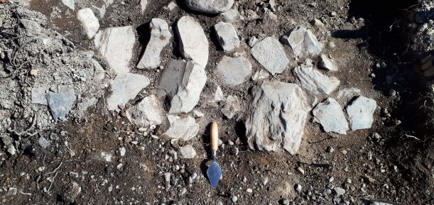
17th-century building rubble from the brewhouse dismantling. We found lots of early-mid-17th-century objects between the fallen stones, as well as rich organic soil, charcoal, burned bones, and other organic material. Photo by author, 2017.
It’s time.
The trowels are cleaned*, the boots are dusted off**, and the car is ready and full of excited and bright eyed volunteers***. The fieldwork season has begun!
*it’s never really going to be clean again, is it?
**Same goes for the boots, they are as dusty as ever
*** No one is that bright eyed at 6:30AM!
If you remember from my last post, I had indicated where I was going to be excavating this summer by a large circle on the map. Of course, I’m not going to be digging literally all of the space inside that circle but a few select trenches to get a better idea of what is going on in the subsurface.
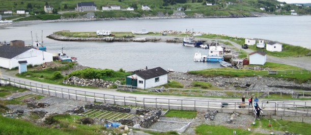
The first trench laid out over the gravel slope. It’s mostly slopewash and debris from above, and parts of the area were previously excavated so the ground lever was actually much higher than it currently appears to be! Photo by author, 2017.
Tomorrow is the day! The 2017 excavation at Ferryland is finally going to start and I couldn’t be more excited! (That’s a lie, I will be more excited when I get on site tomorrow). I wanted to take this opportunity to tell you all a bit more about this year’s excavation and where I am taking it for the next 4 weeks. I’ll be blogging every week about the latest adventures and finds as well and I hope you all come along for the ride!
Map made by Robyn Lacy & Bryn Tapper, 2017.
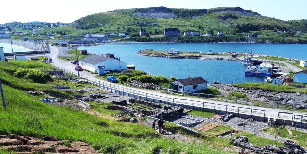
This is a map I made under the guidance of Bryn Tapper, a PhD candidate in my department who knows way more about GIS that I do! It’s an aerial photo of the Ferryland harbour, centered on the 17th-century British settlement area in the Pool, with a later, known burial ground circled in red on the left side of the image. The Pool refers to that little curl of land in the middle of the image, which formed naturally, if you can believe it! It’s the perfect little protected harbour, and deep enough to bring ships into, making it a wonderful location for a small settlement 400 years ago. Continue reading →
I did say that my next post was going to be about the Ferryland gravestones, so here we are! Before I can get into the stone analysis bit though, we first need to discuss death at Ferryland.
Ferryland had long been known as a good harbour before the establishment of the 1621 settlement. In fact, there have been Beothuk hearths found at Ferryland, but their relationship (if any) with migratory European fishermen prior to the settlement being founded is unknown. The natural spit that juts out into the water creates a protected harbour, breaking waves and keeping boats sheltered from the harsh Atlantic storms. It was a natural place for people to want to live, and to die. Continue reading →
In a place often referred to as ‘The Rock’, it sounds a bit redundant to be importing gravestones, but for a period in the 18th-early 19th century, that is exactly what people in Newfoundland were doing. By people, I of course mean people who could afford to have gravestone carved overseas and shipped across the ocean. There are locally carved gravestones as well going back to the 17th-century! I even have a puzzle for all of you gravestone enthusiasts out there, but we’ll get to that in a moment. Continue reading →
Archaeology isn’t quite like they show it in the movies or on Time Team. Of course, we all wish we could just walk into an area, feel the wind, and know exactly where a site is but unfortunately it doesn’t work like that (and we usually have more than 3 days if excavations are happening too)!
Last summer during my excavation at Ferryland, there were quite a few moments that started out feeling as if we’d found something very dramatic, which quickly dissolved into mild disappointment and sighs. But that’s archaeology right? If you’re doing a project that is looking for something, rather than trying to see what was happening in general, then there are going to be a lot of empty test pits. This one wasn’t empty though…

 I’m excited to be able to share my public burial archaeology paper, “Public Engagement through Burial Landscapes: Cupids and Ferryland, Newfoundland” with all of you!
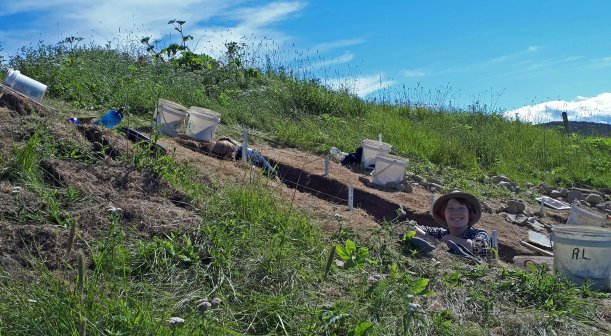


 In a place often referred to as ‘The Rock’, it sounds a bit redundant to be importing gravestones, but for a period in the 18th-early 19th century, that is exactly what people in Newfoundland were doing. By people, I of course mean people who could afford to have gravestone carved overseas and shipped across the ocean. There are locally carved gravestones as well going back to the 17th-century! I even have a puzzle for all of you gravestone enthusiasts out there, but we’ll get to that in a moment.
