Spade & the Grave

death and burial through an archaeological lens


2 Comments

Burial by the Sea: Historical Burial Ground excavation in Newfoundland

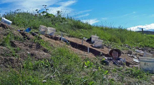
From 2016 – 2017, I was involved in a project to excavate a settler burial ground in Foxtrap, Newfoundland. The excavation was run by Dr. Vaughan Grimes and Maria Lear of the Archaeology Department at Memorial University of Newfoundland, and is under an active archaeological permit through the Provincial Archaeology Office (PAO) of the Government of Newfoundland and Labrador throughout post-excavation analysis. A handful of graduate students, including myself, made up the rest of the field crew.

Based on local knowledge and the PAO investigation of the site in 2006, we were already aware that there was likely a burial ground at this location, based on the several erect and laying markers and fragments of gravestone with inscribed text. While no single record appears to exist for who was buried at this site, and it only had one gravestone with inscriptions on it, the identities of most of the individuals interred there will likely remain a mystery (and that one gravestone was broken and out of situ so we have no idea whose grave it belongs to). Plans are already afoot to re-inter the remains nearby once they have been cleaned and studied.

I am honoured to have been part of the team exhuming this site, as it was the first full historical settler burial ground to be excavated in the province, and so much about early populations could (and will) be learned from those who were buried there.
Continue reading


4 Comments

Tales from the Trenches: Ferryland Week 4, 2017. The Final Push

Well here we are, the final week of my Masters excavation! The title of this post may say week 4, but including last year’s dig this would be week 10. Week 10! For a Masters, I believe that is a bit more time spent digging than was necessary for the degree, but in terms of pursuing the questions I was asking… maybe it wasn’t enough time?
We’ll have to wait and see! We got up to quite a bit at Ferryland this week, and I spent part of the week gathering my thoughts about the research, the end of a major part of my project, and what conclusions we can draw from the results.

blog4_7

I’m standing up in this photo! The trench got a little deep towards the end of the week. Photo by Ian Petty, 2017.

Continue reading


1 Comment

Tales from the Trenches: Ferryland Week 3, 2017

Here we are, 3/4 weeks complete for the 2017 field season!
Cumulatively, this makes my 9th week excavating at Ferryland in search of the 17th-century burials. Lets go over what we uncovered this passed week, and then I’d like to talk about visitors to public archaeology sites and what we know so far about the burial ground!

blog3_5

Continue reading


1 Comment

Tales from the Trenches: Fieldwork Week 2, 2017 (or, why does this keep happening?)

Halfway through through the fieldwork season, and I already cannot believe the amount of earth we’ve moved in pursuit of the burial ground! It’s amazing, thank you to the week 1 & 2 crews for all the hard work you put in, I couldn’t have gotten this far without all of you (and your digging hands)!

It was an amazing week over all, so lets dive right in to what we got up to at Ferryland last week:

blog2_3

17th-century building rubble from the brewhouse dismantling. We found lots of early-mid-17th-century objects between the fallen stones, as well as rich organic soil, charcoal, burned bones, and other organic material. Photo by author, 2017.

Continue reading


2 Comments

Search for the 17th-century Ferryland burial ground, 2017: Introduction

Tomorrow is the day! The 2017 excavation at Ferryland is finally going to start and I couldn’t be more excited! (That’s a lie, I will be more excited when I get on site tomorrow). I wanted to take this opportunity to tell you all a bit more about this year’s excavation and where I am taking it for the next 4 weeks. I’ll be blogging every week about the latest adventures and finds as well and I hope you all come along for the ride!

RL_Ferryland_Map_Overview

Map made by Robyn Lacy & Bryn Tapper, 2017.

This is a map I made under the guidance of Bryn Tapper, a PhD candidate in my department who knows way more about GIS that I do! It’s an aerial photo of the Ferryland harbour, centered on the 17th-century British settlement area in the Pool, with a later, known burial ground circled in red on the left side of the image. The Pool refers to that little curl of land in the middle of the image, which formed naturally, if you can believe it! It’s the perfect little protected harbour, and deep enough to bring ships into, making it a wonderful location for a small settlement 400 years ago.
Continue reading


Leave a comment

Tales from the Trenches – Mystery Soil Stains & an Unexpected Discovery

Archaeology isn’t quite like they show it in the movies or on Time Team. Of course, we all wish we could just walk into an area, feel the wind, and know exactly where a site is but unfortunately it doesn’t work like that (and we usually have more than 3 days if excavations are happening too)!
IMG_4538
Last summer during my excavation at Ferryland, there were quite a few moments that started out feeling as if we’d found something very dramatic, which quickly dissolved into mild disappointment and sighs. But that’s archaeology right? If you’re doing a project that is looking for something, rather than trying to see what was happening in general, then there are going to be a lot of empty test pits. This one wasn’t empty though…

Continue reading