A little while ago, we went on a mini-holiday to Saratoga Springs, NY, for the Canada Day long weekend. I was very excited to do several things I’ve always wanted to do in Saratoga:
a) Visit some of the springs / drink out of them
b) See a burial ground (literally any, how did I miss doing this last time I was there?)
c) swim in the Victoria pool (this one was added a few weeks before the trip when I found out the pool existed. Totally worth the trip!)
Welcome to the Putnam Burying Ground, which we did not think to call ahead to and therefore couldn’t actually go inside!
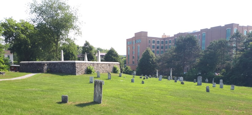
View of the Putnam Burial Ground from the street, with the Putnam Family Plot to the left of centre (photo by author, 2018)
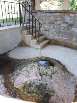
High Rock Spring (photo by author, 2018)
Saratoga Springs, located in upstate New York, was built around the naturally occurring springs that exist in many locations across the town. The springs were known about and used by the Mohawks and other Indigenous groups, who believed that the naturally bubbling waters had healing properties (Saratoga Springs Heritage Area Visitor Center 2018a).
The belief in the medicinal properties of the water has continued to this day, with various springs around the area being touted for their digestive benefits (as gross as one of those springs tasted, it did settle my stomach, so I’m going to go ahead and be on team magic-springs). Out of the multiple springs in the area, High Rock Spring, the original spring utilized by the Indigenous peoples for years prior to Europeans arriving in the area, was the least terrible-tasting out of the 4 or 5 springs we visited (if it hadn’t been boiling outside, this list would be longer)
The town formed later than many Euro-American settlements in the area, with its earliest plan having been drawn up in the late 18th century, and became an established settlement by 1810 after Gideon Putnam aquired land in the area, and maps were made of his properties which now comprise the downtown core of the town as we know it today.
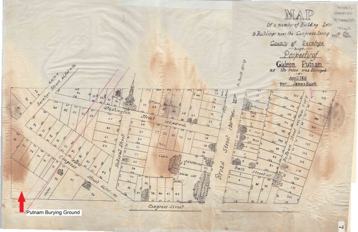
Copy of the James Scott 1810 map of Putnam’s properties in Saratoga Springs (Scott 1810, retrieved from the Mapping Saratoga Springs Project)
Putnam planned the space for the burial ground into the original settlement layout, placing it on a sloped piece of land, on the southwest corner of the settlement plan. This uneven landform wouldn’t have been ideal for building houses or farming, which makes it an excellent candidate for a burial ground! Today the burial ground holds approximately 150 graves, including the large walled family plot for the Putnam Family.
Unfortunately when we visited, the burial ground was locked and we were unable to find a way inside that didn’t involve climbing a fence, but it is definitely a site that I’d like to visit in the future. I’m sure the gravestones for the Putnam family are very interesting!
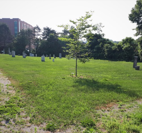
Putnam Burying Ground, view from the fence (photo by author, 2018)
What I find particularly cool about the Putnam Burying Ground is that Gideon laid out the properties you see mapped above after himself and his wife Doanda moved to the area in 1789, and while clearing the land he recognized the series of springs along a fault line and decided to capitalize on them by opening a hotel and other amenities such as a spa resort for C19th tourists. Because he organized a lot of the utilization of this area, it means that he also planned and laid out the burial ground for that specific function within the town!
While some sources say that the burial ground was expressly for the Putnam family originally (Sacred Spaces of Saratoga 2012), the fact that the burial space is set aside in early maps, prior to the date of 1825 when it was apparently donated to the town as a burial space for the settlement, suggests that the purpose of the space was as a communal burial ground for some time prior, if not intentionally from the start. The Saratoga Springs Heritage Area Visitor Center (2018b) page on the site suggests that the land was indeed donated as a burial ground for the town originally, and contains a plot of land set aside as the family burial plot for the Putnams.
While some burial spaces are born out of necessity, others are planned ahead of any deaths and sit empty for months or years before they are used. The pre-planning of burial spaces is something that I find every interesting, and says a lot about how that group of people responded to the concept and reality of human mortality. Putnam had this land set aside for the express purpose of burying the dead on the outskirts of town, which is in-line with the trends in the late C18th and early C19th trends in removing burial spaces from the often over-crowded centers of towns to the outskirts. This was a physical removal of death from the direct public eye, and a common theme in the period, as I discussed earlier in my post about the Guilford Green.
Ironically, and perhaps terribly, Gideon Putnam was in fact the first person to be buried in his own burial ground, after he fell from a scaffold while working on the Union Hall and was killed.
If you are in the area, you can call the Saratoga Springs Heritage Area Visitor Center to arrange getting access to the burial ground, which is something I am definitely going to do the next time I’m in the states!
Work Cited:
Sacred Spaces of Saratoga. 2012. Gideon Putnam Burying Ground. Available online at: http://sacredsaratoga.weebly.com/gideon-putnam-burying-ground.html
Saratoga Springs Heritage Area Visitor Center. 2018a. History of Saratoga. Available online at: http://www.saratogaspringsvisitorcenter.com/about-saratoga-springs/history-of-saratoga
Saratoga Springs Heritage Area Vistor Center. 2018b. Gideon Putnam Cemetery. Available online at: http://www.saratogaspringsvisitorcenter.com/things-to-see-do/history/gideon-putnam-cemetery
Scott, James. 1810. Map of a number of building lots near the Congress Sporing in the Town of Saratoga Springs in the County of Saratoga: Being the Property of the Heirds of Gideon Putnam deceased as the same was surveyed in April 1810. Mapping Saratoga Springs. Available online at: http://ssmp.skidmore.edu/exhibits/show/mappingsaratoga/space_time/map_timeline
