It’s been a while for this series, hasn’t it? Today we will be exploring a historically very rural site, the Ellis Chapel, which is located in Puslinch Township, Wellington County, Ontario. The chapel can be accessed from the parking lot of the Cambridge On Route off the 401, west-bound, or from Ellis Road. The address of the site is: 6705 Ellis Rd, Cambridge, ON, N3C 2V4.
While this site is mostly known for its historic, coursed masonry chapel, constructed in 1861, the grounds include a small graveyard. Let’s take a closer look!

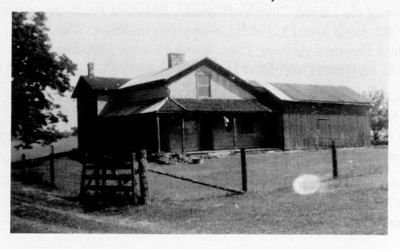
Rear of the chapel, as seen from the south (photo by author 2020).
The Ellis Chapel and graveyard was established in 1861, with the construction of the chapel itself. It is a one storey, coursed masonry church structure with a medium gable roof and projecting eaves and verges. The property is located on a subdivided portion of land that was owned by Edward Ellis on the Guy Leslie Map from 1861, the same year the chapel was constructed. It’s located on the south half of Lot 9 Concession 2, Wellington County, as can be seen on the map below.


The Leslie Map indicated that the church was originally a Methodist Church, and it is marked with a star on the 1877 Walker & Miles map, also pictured above, although the lot was owned by W. Ross at that point, and another structure is shown to the southeast of the chapel.
The Ellis Homestead, occupied by Edward and Mary until 1873, William Ross until 1946, and by George & Winnie Lambert until 1956. The structure is no longer standing (Ellis Church Board 1987)
Edward Ellis arrived in the area in 1839, purchased the deed to the south half of Lot 9 Con 2. He married Mary McMaster in 1841, and in 1859 an agreement was given by the couple to ‘the Trustees of the Sterling Congregation of the Wesleyan Methodist Church of Canada’ and the church was constructed two years later (Ellis Church Board 1987).
It took two years to construct the chapel, and the builders included Edward Ellis and his brother Thomas, and much of the masonry was collected from nearby farm fields, as was typical of stone structures in an agricultural community. It would be assumed that the burials began around the same time as the church construction, however the church records stated in 1888:
“...as it [the burial ground] has not been open to the public for 30 years, for we felt too feebly financially to clear up and fence in the cemetery until the summer of 1873…The acre of land upon which out church stands was given free of cost, not sold, expressly for the purpose of burial ground in connection with the erection of a church for the use of this locality.” – Thomas Ellis, 1888.
Contrary to this statement, however, are gravestones below which predate 1873, suggesting that burials were taking place before this date. The church does not have many records of the graveyard, unfortunately, and it appears to have taken the remaining marble gravestones and placed them together in a cobble ‘cairn’ at the southwest side of the property, in 1965.


The gravestones pictured above are the only remaining historic gravestones present at the site, affixed in the cairn, and all carved by the same carver, ‘FEAST, GUELPH’, and depict the same simplistic dove on the top of each stone. I’ve never seen that particular style of dove before, and it’s lovely! The church indicated that there are likely only between 16-20 burials at the site, mostly of children who died from illness such as typhoid fever, cholera, and scarlet fever (Ellis Church Board 1987). If you know anything more about this carver, I’ve not been able to find any information on them yet!
As you’ll know if you’ve been following my blog for a while, or if you are well-versed in gravestone conservation, placing soft stones (like marble) into harder substances (like concrete) is generally considered to be a bad idea. It used to be a common part of conservation for historic burial sites to reset gravestones using concrete, and to place them in these cairn like structures as well…unfortunately we know now the damage that this can do to the stones because moisture is trapped inside and causes them to weather quicker. It is also very difficult to get them back out, as chiseling concrete often causes damage to the already-weakened, fairly granular marble. So it’s a little sad to see stones like this, but overall, the church and grounds are beautifully preserved, and was a welcome change from the typical On Route 401 stop attractions!
Thank you for reading, and following the series! If you have any additional information you’d like me to add to this post, please drop a comment below.
")

References:
Ellis Church Board. 1987. Ellis Church: Enduring and Everlasting. Available online: http://www.clarksoftomfad.ca/EllisChapel.htm
Leslie, Guy. 1861. Wellington County Map. Ontario Historical County Maps Project. Available online: http://maps.library.utoronto.ca/hgis/countymaps/wellington/index.html
Walker & Miles. 1877. Puslinch in the 1877 Wellington County Map. McGill University’s Digital Atlas Project. Available online: http://digital.library.mcgill.ca/countyatlas/showtownship2.php?townshipid=puslinch
